Daytona Beach to Jekyll Island GA
—Blogpost written by Bob
Daytona Beach to St. Augustine
At about 6:30 PM last evening a boat neighbor came by in his dinghy to alert us that our anchor was dragging. We were both below reading. Our boat ended up abeam to a moored boat and we were fortunate that no harm was done to either boat. We were able to raise our anchor and motor away simultaneously but it was kind of a freaky occurrence. We moved about 1/2-mile upwind and re-anchored—this time the anchor dragged immediately because I think the anchor chain was dropped in a big pile right on top of the anchor (or we snagged some debris on the bottom), not allowing it to dig in as it should. We re-anchored the second time, tested it with the engine in reverse, and then installed the anchor bridle. The anchor bridle, in addition to acting as a shock absorber, lowers the point where the horizontal force (created by the wind against the boat) is applied to the anchor (because a big loop of heavy chain holds it down). I stayed in the cockpit until sundown when I felt assured it would not drag again.
We weighed anchor at 6:40 AM on Monday, May 4 (taking a little extra time to remove the anchor bridle we installed last evening) and headed north on the ICW through the myriad of bridges in Daytona Beach—there were five of them (and one had two spans and another was a bascule bridge) that crossed the Halifax River!
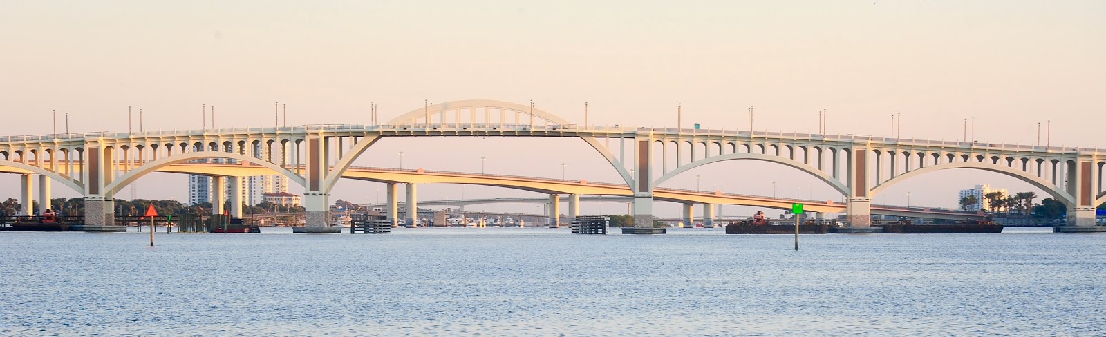 |
| The morning sun shining on five bridges that lie in front of us heading north on the ICW from Daytona Beach. |
We made good time getting through Daytona Beach and beyond, riding a 1/2-knot tidal current—we were moving at 7+ knots! By 8:30 AM the tide went slack and we lost the favorable current. Another bridge (L.B. Knox) opened for us and another sailboat at 8:45 AM.
 |
| The L. B. Knox Bridge opening for us and one other sailboat. |
Sure enough, just a short time later, the tidal current was against us. With the many large waterfront homes and condos on this stretch, there were many interesting things to see. We passed Palm Coast which I remember from my first trip to the Bahamas over 25 years ago.
 |
| A home near Matanzas Inlet that gives a whole new meaning to living on the water. |
We made it to St, Augustine Municipal Marina by 2 PM and we topped off our primary diesel tank (22.8 gallons since Fort Pierce!) and got some fresh water and ice.
 |
| St. Augustine is such a beautiful sight from the water! |
We made it through the 2:30 opening for the Bridge of Lions to capture our rented mooring ball (N-6) for the night. It felt strange not going into town for pizza at Pizza Time and just the casual roaming around town. This was always one of our favorite stops along the ICW and it still is.
St. Augustine to Fernandina Beach
It was easy just letting go of the mooring line this morning. We departed St. Augustine at 7 AM on Tuesday, May 5, 2020 as we started a 52-mile day toward Alligator Creek (our expected last stop in Florida).
The sky was overcast and the temperature was a cool 67 degrees F as we rounded the green buoy near the St. Augustine inlet and headed up the Tolomato River. The clouds cleared up by nine in the morning.
We passed through Palm Valley with their luxury homes situated right along the ICW. (The construction of the ICW was as much a boom to builders as for boaters!) As we approached the St. John’s River the tidal current increased greatly—the tide was going out. At one point going under a bridge where the tidal flow was constricted to a narrow width our boat speed increased to a whopping 10.2 knots! After the constricted area we maintained a boat speed of 8+ knots until we had to turn into the river and go slightly upstream—then our boat speed dropped to dramatically to 3.5 knots. (There are huge ships that transit the St. John’s River and we needed to be careful because we couldn’t get out of their way very quickly the way our boat speed had diminished.)
We got across the St. John’s River and headed further up the ICW with the tidal current against us all the way. We were moving at less than five knots most of the time (until the tidal current started to slacken).
 |
| An area of the ICW just north of the St. John's River. |
We determined our (Alligator Creek) anchorage so that we would have high tide in the morning to avoid delays in the Fernandina Shallows, just south of Fernandina Beach FL. However, when we arrived late in the afternoon, the tide was one foot below the normal low and we couldn’t find enough water depth to anchor. We went aground for about 1-1/2 hours, waiting for the tide. We eventually motored off and followed TowBoatUS into Fernandina Beach—they were towing another sailboat.
 |
| In this pic you can see a TowBoatUS towboat towing a sailboat as we all wait for the last couple railroad cars to cross the bridge. |
It was 4:30 PM when we got settled on our mooring buoy. We put in a 60-mile day today and we were beat, mostly from battling the mooring buoy at Fernandina Beach in the heavy tidal flow. One advantage of the long day today is that tomorrow will be only a 33-mile day.
 |
| Looking south in the mooring field with one of two paper mills in the background. |
It's been a long time since we stopped at Fernandina Beach because the marina was wiped out by a hurricane (Michael) a couple years ago. It was just finished being rebuilt this Spring.
Fernandina Beach FL to Jekyll Island GA
We dropped our mooring pennant at 6:50 AM on Wednesday, May 6, bound for Jekyll Island GA. The sun was just coming up over the paper mill in Fernandina Beach.
 |
| One of two paper mills in Fernandina Beach this morning as we're leaving. |
We had breakfast (egg sandwiches) while underway. It was cool with a brisk wind out of the west and we wore sweatshirts to keep warm. Riding an incoming tide (doing 7+ knots boat speed) up the Amelia River, we slowly passed Cumberland Island, GA.
We had a favorable tidal current most of the morning and made it to Jekyll Harbor Marina by 11:40 AM. It was a 33-mile trip and we made it in exactly 4 hours and 50 minutes (4.83 hours) for an average speed of 6.83 miles per hour (5.94 knots).
At the marina, we had lunch out for the first time since the start of the pandemic! We ate outside at tables that were at least six feet apart. The food was great!
After lunch I changed the engine oil and filter. In the process I found a dripping hose connection on the water heater—the plastic fitting was cracked. Fortunately I had a brass/bronze replacement fitting and I simply changed out the fitting. (This may have been the source of our fresh water leak that we had been looking for.)
 |
| There was a longitudinal crack in the hose barb end of this plastic fitting. |
While in the mood for work, we emptied our composting toilet’s solids container—it was not very messy and rather easy this time. We got all this work done one hour before Happy Hour!
 |
| S/v Rainy Days at rest along the face dock at Jekyll Harbor Marina. |
A summary of our travels (in statute miles) since leaving Great Exuma, Bahamas on Sunday, April 19:
From Great Exuma to Ft. Pierce, FL = 405 miles (ocean)
From Ft. Pierce FL to Jekyll Island GA = 282 miles (ICW)
Total traveled to date (May 6) = 687 miles (ocean + ICW)
Miles to go (to Baltimore) = 854 miles (ICW)
----------
Our next blogpost follows our trek through the remainder of Georgia--our least favorite state to transit.
Stay healthy and thanks for following our blog!
No comments:
Post a Comment